Glacier Park

Our Favorite Businesses
Follow Us
On Social

Red Gap Pass Trail
Includes Poia Lake, Red Gap Pass

Red Gap Pass, Glacier National Park
Red Gap Pass Trail
Trailhead: Red Gap Pass Trailhead, two miles east of Many Glacier Hotel
Distance: 29.4 miles (one way) if returning to Red Gap Pass Trailhead.
Elevation Gain: 5,617 vertical feet!!!
Elevation Loss: 5,531 vertical feet!!!
 The Red Gap Pass Trail in Glacier National Park is located in the Many Glacier Area. This is one of only two multi-day hike "loops" in Glacier Park, where you can end up where you started without needing a shuttle pick-up or a second vehicle. This is probably why this multi-day Glacier Park hike is fairly popular.
The Red Gap Pass Trail is not among our "Favorite Multi-Day Hikes" in Glacier National Park, but it's still a very nice yet strenuous hike.
Notice you are gaining 5,631 vertical feet and losing 5,531 vertical feet on this hike if you start and finish at Many Glacier, so make sure to keep your backpack light or you will really pay for the extra weight!
Another interesting aspect of this multi-day hike is that there are only two backcountry campgrounds available the entire hike, and they are about 10.2 miles apart from one another... And between these two campgrounds is Red Gap Pass, where you must climb over 1,500 vertical feet in 2.5 miles, then drop 2,500 vertical feet in 4.6 miles.
Poia Lake Day Hike
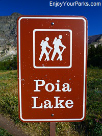 The first section of the Red Gap Pass Trail in Glacier National Park takes hikers to Poia Lake, which also makes for a nice day hike for those visiting the Many Glacier Area not interested in a multi-day hiking adventure. HOWEVER, the day hike to Poia Lake is not among our favorite day hikes in the Many Glacier Area, which include the Grinnell Glacier Trail, Swiftcurrent Pass Trail, Iceberg Lake Trail, Ptarmigan Tunnel, and Cracker Lake Trail. So we recommend that you do not spend the day hiking to Poia Lake until you've first hiked these world-class hikes in the Many Glacier Area that we just listed above.
Finding The Trailhead
The Red Gap Pass Trail in Glacier National Park is located in the Many Glacier Area, and it begins along the Many Glacier Road about 1.9 miles east of the Many Glacier Hotel. You'll see a small parking area along the north side of the road. MAKE SURE you take the Red Gap Pass Trail and not the trail to Apikuni Falls! We've met several backpackers through the years who ended up in the Apikuni Basin because they were confused by the trail signs. The Red Gap Pass Trail is a popular multi-day hike in Glacier National Park probably because it's one of the few "loops" where hikers do not need to set up a shuttle pick-up or rent a second car. However, it's not among our "Favorite Multi-Day Hikes" in Glacier National Park.

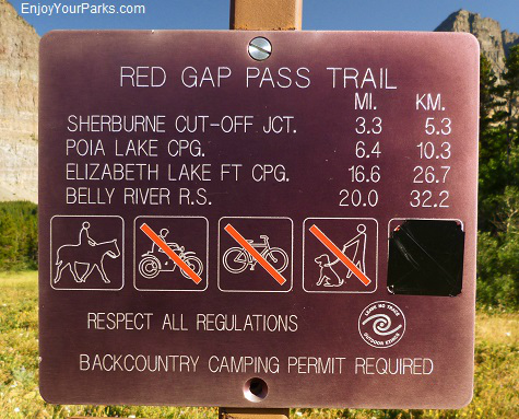
This is a photo of the trailhead to the Red Gap Pass Trail along the Many Glacier Road in Glacier National Park, which includes Poia Lake.
Red Gap Pass Trailhead (mile 0.0)
 We call the first section of the Red Gap Pass Trail the "YoYo Hike" because it's so "Up and Down". The Red Gap Pass Trail in Glacier National Park first climbs 1,223 vertical feet to what is known as Swiftcurrent Ridge at mile 3.6, then drops about 700 vertical feet into Kennedy Creek Valley at mile 4.9 before you
must climb another 500 vertical feet to reach Poia Lake. Along the top of the Swiftcurrent Ridge, you'll see a small, marshy lake to the right called the Swiftcurrent Ridge Lake.
Note: At about mile 3.3 you will see the Sherburne Cutoff Trail junction that connects the cut-off trail that starts at the park entrance at Many Glacier. Make sure you stay left to continue onward to Poia Lake.
From the top of Swiftcurrent Ridge, you will get a good view of Lake Sherburne and Mount Wynn to the south. Once you drop northward into the Kennedy Creek Valley, you can't help but notice Yellow Mountain to the northeast, and Apikuni Mountain directly to the south as you reach Poia Lake.
Poia Lake / Poia Lake Campground (mile 6.4)

Poia Lake along the Red Gap Pass Trail in Glacier National Park.
 Near Poia Lake, you will hike by the Poia Lake Campground, which is a popular stop for those overnight backpackers who are hiking to Red Gap Pass via the Kennedy Creek Valley and then down to the Belly River Valley. Once these backpackers reach the Belly River, they can either head northward to the Chief Mountain Customs Trailhead, or head southward through the Ptarmigan Tunnel and then back to the Many Glacier Area. Either way, these overnight backpackers will likely stay at Elizabeth Lake for their second night before they head north or south. (See map below)
At Poia Lake, you will see the massive Apikuni Mountain to the south, Yellow Mountain to the northeast, and far in the distance up the Kennedy Creek Valley you'll see Crowfeet Mountain, and the red ridge where Red Gap Pass is located.
From Poia Lake, the Red Gap Pass Trail in Glacier National Park ascends very gradually up the Kennedy Creek Valley as it heads straight west towards Red Gap Pass. Apikuni Mountain is to your left (south) and Crowfeet Mountain is straight ahead of you near the head of Kennedy Creek. Make sure to enjoy this pleasant 3 mile section of the Red Gap Pass Trail, as once this section is over, it's all uphill... and then downhill... and then uphill after that!

A view of the Kennedy Creek Valley from Poia Lake along the Red Gap Trail in Glacier National Park.
The Climb to Red Gap Pass (mile 9.4)
About 3 miles from Poia Lake along the Red Gap Pass Trail in Glacier National Park, the trail begins to work its way up to Red Gap Pass. This is where the fun begins! The trail climbs quite abruptly about 1,534 vertical feet in less than 2.5 miles. There are 2 series of switchbacks, but you'll wish there were more. When you get close to the pass, you'll know why this pass is called "RED" Gap Pass because the rock is literally bright red! (known as Grinnell argillite)! Of course the view gets better and better the higher you get. There is also an unnamed glacial tarn just below the pass.

A view of the Red Gap Trail from Crowfeet Mountain in Glacier National Park.

A view of Red Gap Pass from the summit of Mount Henkel in Glacier National Park.
Red Gap Pass (mile 12.0)
After climbing 1,534 feet in less than 2.5 miles, you will reach the bright red Red Gap Pass, elevation 7,520 feet above sea level. The instant you reach Red Gap Pass you will be greeted by the famous Old Sun Glacier and gigantic Mount Merritt to the west, and the deep Belly River Valley far below you with Elizabeth Lake peering up at you. Straight above you to the northeast is the bright red Seward Mountain. To the south you will see Kennedy Lake, Mount Henkel and Crowfeet Mountain, and to the southeast looms the massive Apikuni Mountain. The views from Red Gap Pass are quite remarkable, so take your time as you catch your breath, and take it all in.

Red Gap Pass as viewed from Apikuni Mountain in Glacier National Park.
"What Goes Up Must Come Down"
You all know the saying "what goes up must come down." Well this statement certainly fits Red Gap Pass in Glacier National Park! Once you've rested, it's now time to drop down the west side of Red Gap Pass into the Belly River Valley. This is a rather steep descent in a fairly short amount of time, where you will drop over 2,500 vertical feet in just over 4.5 miles.
Ptarmigan Trail Junction (mile 14.6)
About 2.6 miles into your descent into the Belly River Valley from Red Gap Pass, you will encounter the Ptarmigan Trail junction. This trail takes hikers up through the Ptarmigan Tunnel and then down to the Swiftcurrent Motor Inn parking lot in the Many Glacier Area. This junction is where you must hike back up to after spending the night on Elizabeth Lake if you're heading for the Many Glacier Area the next day.

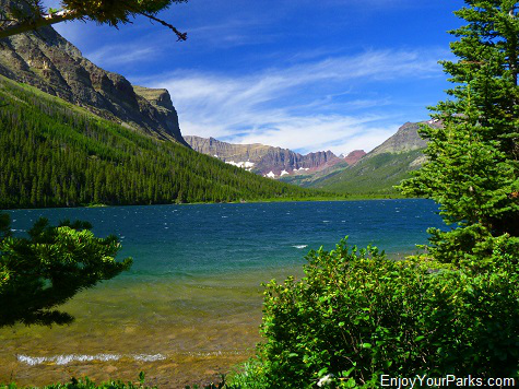
Belly River Valley and Elizabeth Lake.
Elizabeth Lake / Elizabeth Lake (Foot) Campground (mile 16.6)
After descending over 2,500 vertical feet from Red Gap Pass in about 4.6 miles along the Red Gap Pass Trail, you will finally reach Elizabeth Lake in the Belly River Valley of Glacier National Park. You will be staying the night at the Elizabeth Lake (Foot) Campground, provided you have a reservation.
Click Here for more information on the Belly River Valley, including Elizabeth Lake.
Ptarmigan Trail Junction (mile 18.6)
If you are heading for the Many Glacier Area the next day, after you spend the night at the Elizabeth Lake (Foot) Campground, you then must back-track up the Red Gap Pass Trail about 2 miles to reach the Ptarmigan Trail junction. From there, head south along the Ptarmigan Trail as it will take you up through the Ptarmigan Tunnel, and then down to the Swiftcurrent Motor Inn parking lot in the Many Glacier Area.

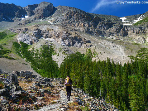
Shannon heading up the Ptarmigan Trail toward Ptarmigan Tunnel in Glacier National Park. Ptarmigan Tunnel is about 2,500 vertical feet higher than Elizabeth Lake.
Click Here for more information on the Ptarmigan Trail.

This is a view of the Ptarmigan Trail from the summit of Crowfeet Mountain in Glacier National Park.
Swiftcurrent Motor Inn Parking Lot (mile 26.4)
Once you hike up to and through the Ptarmigan Tunnel along the Ptarmigan Trail in Glacier National Park, you will then gradually descend down to the Swiftcurrent Motor Inn parking lot at Many Glacier, which is 9.8 miles south of the Elizabeth Lake (Foot) Campground. Oh and by the way, from Elizabeth Lake, you will be climbing about 2,500 vertical feet to reach Ptarmigan Tunnel, and then descending about 2,400 vertical feet to reach the Many Glacier Area!
Red Gap Pass Trailhead Parking Lot (mile 29.4)
From the Swiftcurrent Motor Inn parking lot, you then must hike along the Many Glacier Road about 3 miles to return to your vehicle that's parked at the Red Gap Pass Trailhead parking lot. You have just hiked 29.4 miles, and gained/lost a total of 11,148 vertical feet...Hopefully you packed light and you were in good shape!

Poia Lake along the Red Gap Pass Trail

Share This Page On Social:
