Glacier Park

Our Favorite Businesses
Follow Us
On Social

Gable Pass

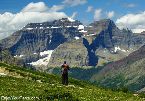
Gable Pass with a view of Chief Mountain, Glacier National Park
Gable Pass
Trailhead: Lee Ridge Trail. Mile 17.8 on the Chief Mountain Highway
Location: (about 0.2 miles east of Chief Mountain Customs Trailhead parking lot)
Distance: 6.3 miles (one way)
Elevation Gain: 1,700 vertical feet
Gable Pass in Glacier National Park is most easily reached by hiking the Lee Ridge Trail. The Gable Pass / Lee Ridge Area is not one of the most popular hikes in Glacier National Park simply because not many people know about it. However, this remote area is in fact one of our favorite areas in Glacier Park because of the unique geology and scenery, and it's a great place to get away from it all.
Finding the Lee Ridge Trailhead
 The best way to find the Lee Ridge Trailhead for the first time is to drive on the Chief Joseph Highway (Highway 17) to the Chief Mountain Customs Trailhead, which has a large parking area located just before you reach the U.S./Canadian border crossing.
Turn your car around and drive less than three hundred yards until you see a small pullout area to your left (north). Park here. Now to find the actual trailhead, simple walk east along the highway for only about 200 yards and look for the Lee Ridge Trailhead sign on the right-hand side of the road (south).
The sign is quite hidden in the trees so look for it carefully. If you're looking for it before the sun comes up, look for a reflector with your headlamp.
Lee Ridge Trail
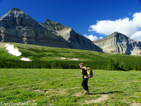 The Lee Ridge Trail is a wonderful 6 mile hike that first takes you through a lodge pole pine forest and then through an incredible alpine meadow with outstanding views of Mount Cleveland, Gable Mountain and Chief Mountain. The view alone makes this an outstanding Glacier Park hike. (We call this alpine meadow the "Sound of Music meadow".) When the trail reaches this open alpine meadow (at about mile 3.5), the trail disappears and you then must look for cairns (piles of rocks) that are strategically placed about every 50 yards or so.
The Lee Ridge Trail in Glacier Park then climbs a bit more steeply until it connects with the Gable Pass Trail at the 6.0 mile mark. The actual pass is approximately 0.3 miles west of this junction. From Gable Pass you can then head down 1,200+ vertical feet to Slide Lake to the east, or down to the Belly River Trail and Belly River Ranger Station to the west.
If you're goal is to visit Gable Pass (elevation 7,220 feet) on just a pleasant day hike, once you've enjoyed this beautiful area, simply back-track along the Lee Ridge Trail back to your car parked on the Chief Mountain Highway. Keep in mind that the Lee Ridge Trail is not a maintained trail, but it is very easy to follow (as of August 2012).
Water Situation:
Depending on the summer, there is usually a small pond that is created by the melting of a large snowfield below you to the north once you've reach the Lee Ridge Trail / Gable Pass Trail junction. However, you cannot count on this snowfield to be there so bring enough water with you to get you there and back. There is also a creek in the same area but again, sometimes it's dry. There is no other water source along the Lee Ridge Trail, so keep all this in mind.
Alternative Route: Slide Lake Trailhead
You can get to Gable Pass from Slide Lake, but it's quite a steep climb (about 1,500 vertical feet in about 1.7 miles), and the scenery is not nearly as remarkable as the Lee Ridge Trail route. The trailhead to Slide Lake is located about 0.3 miles southeast of the Chief Mountain Overlook. There will be a sign near a barb wire fence that says something like "No camping aloud on the Blackfeet Reservation without a permit" or something to that effect. That marks the beginning of the trail to Slide Lake.
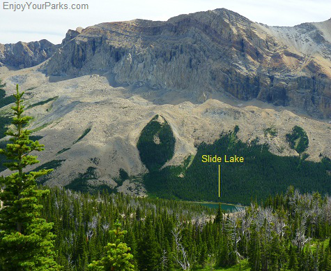 Slide Lake is approximately 8.6 miles from this trailhead, and there is a backcountry campground near this location (mile 8.4). At the lake you will see a trail sign indicating the junction and trail to Gable Pass.
Gable Pass is about 1,500+ vertical feet above the lake, and the distance to the pass is only about 1.7 miles. That's quite a steep hike and is not enjoyed by backpackers whose packs are too heavy!
The hike to Gable Pass via the Lee Ridge Trail is a very enjoyable Glacier Park hike. It is definitely "off the beaten path" so you won't see a lot of other hikers there, and the scenery is fantastic. Because of this, the Gable Pass / Lee Ridge Area is one of our favorite Glacier National Park hikes. It is truly a special place that we always enjoy no matter how many times we visit it.
 from Lee Ridge in Glacier Park.")
A view of Chief Mountain, Ninaki and Papoose (left to right) from Lee Ridge in Glacier Park.

Share This Page On Social:
