Waterton Lakes

Our Favorite Businesses
Follow Us
On Social


Bertha Lake, Waterton Lakes National Park
Bertha Lake Trail
Includes Lower Bertha Falls, Bertha Lake Campground, Waterton Lakeshore Trail, Bertha Bay Campground
Trailhead: Southwest corner of Waterton Park Townsite
Distance: 3.4 miles (one way)
Elevation Gain: 1,487 vertical feet
Elevation Loss: 168 vertical feet
 The Bertha Lake Trail is among the many popular Waterton Lakes National Park hikes, and we always enjoy ourselves on this wonderful hike. This fairly short day hike takes you to a gorgeous sub-alpine lake surrounded by towering cliffs and mountains. The Bertha Lake Trail is definitely among our "Top Ten Things To Do In Waterton Lakes National Park", and we highly recommend it to anyone interested in a rather short day hike that lands you into an incredibly scenic landscape.
Finding the Trailhead
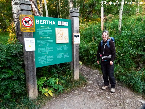
The Trailhead to Bertha Lake in Waterton Lakes National Park is located at the southwest corner of the Waterton Park Townsite. The Bertha Lake trailhead is located just west of the large townsite campground, and there is an obvious sign showing you the way. When you get to the trailhead of Bertha Lake, there is a parking lot with plenty of room for a fair number of vehicles.
The Hike To Bertha Lake: Trail Sign (mile 0.0)
The hike to Bertha Lake initially follows the shoreline of Upper Waterton Lake. You will hike through aspens and evergreens, all the while enjoying really nice views of the lake as you head southward.

The first section of the Bertha Lake Trail takes you along the shoreline of Upper Waterton Lake in Waterton Lakes National Park.
Waterton Lakeshore Trail Junction (mile 0.9)
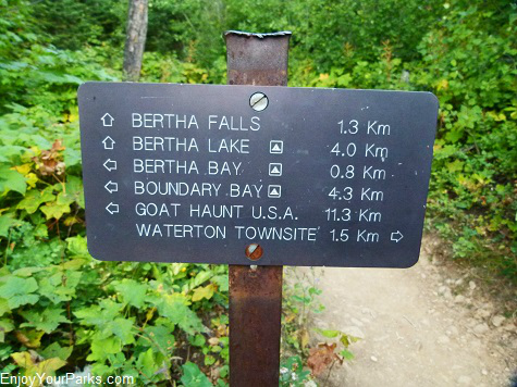 In about a mile into your hike to Bertha Lake in Waterton Lakes National Park, you will encounter the Waterton Lakeshore Trail Junction.
The Waterton Lakeshore Trail takes hikers all the way to Goat Haunt Montana, which is about 7.5 miles south of where you are standing.
This is the only trail to Goat Haunt Montana from Waterton Townsite. The most popular way to get to Goat Haunt, and by far easier, is by taking the Waterton Lake Boat Tour.
Just about a half mile from this junction rests Bertha Bay and the Bertha Bay Campground along the Waterton Lakeshore Trail To get to Bertha Lake, take a right at this junction.
Lower Bertha Falls (mile 1.9)
 At just about the 2 mile mark, you will encounter a well-built foot bridge. Just beyond this bridge you see Lower Bertha Falls upstream to your right. Early in the season these falls are really quite astonishing, but they are still quite beautiful throughout the summer season as the water cascades down this diagonal outcropping of rock like ribbons.
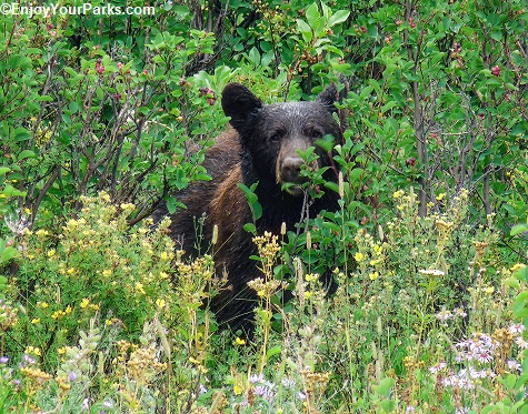
And by the way, there are plenty of black bears on this trail, so make sure you talk loud so you don't surprise any of them! The black bear in the photo to the left was hanging out about a quarter of a mile before we reached Lower Bertha Falls.
Up until this point, you were actually hiking along the "Lower Bertha Falls Self-Guided Nature Tour". The bridge marks the end of this tour.
Beyond the bridge, the Bertha Lake Trail in Waterton Lakes National Park begins to abruptly gain in vertical elevation all the way to the lake. If you are carrying an overnight pack on your back because you're planning on staying the night at Bertha Lake, you are about to get your workout for the day.

Lower Bertha Falls in Waterton Lakes National Park is just to the right of this well-built foot bridge.

Lower Bertha Falls, Waterton Lakes National Park.
As you hike beyond the bridge along the Bertha Lake Trail, the trail really begins to climb in elevation as you enter a sub-alpine forest. Fortunately there are a fair amount of switchbacks that make this section of the Bertha Lake Trail hike a little easier than it would be otherwise. You will definitely get your "cardio" for the day as you hike steeply uphill toward Bertha Lake for the next 1.5 miles.
Bertha Lake (mile 3.4)

Bertha Lake in Waterton Lakes National Park.
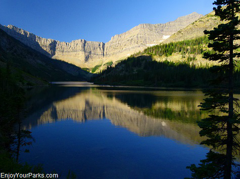 Once you reach the east shore of the sub-alpine Bertha Lake in Waterton Lakes National Park, you'll be very impressed with the view that unfolds before you. Bertha Lake is surrounded by towering cliffs and mountains, that the lake itself is beautiful. This view will make the effort to get there seem very much worth while. Near the lakeshore, you will have a choice to go left or right, as there is a primitive trail that follows the entire lakeshore. To reach the Bertha Lake Campground, take a right. If you want an open view of the lake, take a left.
Bertha Lake Campground
(mile 3.5)
To reach the Bertha Lake Campground, you will cross the outlet stream on a foot bridge, and then hike about a tenth of a mile to the campground. A few hundred yards further you'll find a cooking shelter and picnic area near the shore of Bertha Lake. The trail continues on along the lakeshore, around the entire lake, but it is not maintained by the park service.
Mount Richards looms to the south of Bertha Lake, and the cliffs of Mount Alderson dominate the view to the west. Bertha Peak is directly north of the foot of Bertha Lake.
We always enjoy the hike to Bertha Lake in Waterton Lakes National Park. The view is wonderful, and the hike around the lake is a lot of fun. And the great part about this hike is it's only 3.4 miles (one way), so you'll have plenty of time to explore the primitive trail that surrounds this gorgeous body of water, even if you only go part of the way around Bertha Lake.

Share This Page On Social:
